In the first part I covered the CNJ (abandoned) Mainline through Parsons/Miners Mills, the Gardners Switch area,
and portions of the (extant) former D&H line from North Wilkes-Barre to Hudson.
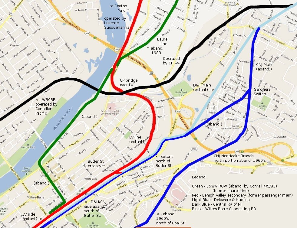
In an earlier set, I covered the CNJ Nanticoke Branch from Coal Street to Ashley.
That line, though now abandoned, actually retains a good deal of its trackage, though broken up.
It was still in use at least into the late 1980's from Ashley to near Coal Street at Wilkes-Barre Township Blvd.
The northern portion of the Nanticoke Branch ran from Gardners Switch (at Gardner Ave/Railroad St in Parsons),
branching off the CNJ mainline and heading south to Coal Street. That line, from the information I currently have,
was torn up much earlier, probably some time in the 1960's. It still appeared on a 1959 aerial photo.
Today, along that entire segment, a very tall green power line follows the exact path of the ROW,
except for several of these poles out of alignment around Coal Street which circumvent the businesses there.
In the map below, we are following the dark blue line at the extreme right:
Here we are at the Gardners Switch site as it looks today (looking north). The CNJ Mainline would have approached
from directly behind us and joined with the end of the Nanticoke Branch, coming from the right, in an upside-down "V".

Turning around, looking south, the Nanticoke Branch ROW followed the path of the power line, directly ahead and to the left.


Here we're looking north at the point where it would have crossed Scott Street...

... and now George Avenue (along its easternmost dead-end block) looking north, then south.


The next street it crossed was Motorworld Drive, and looking to the north you can still see
the abutment for its bridge over Laurel Run (creek).

From there, going south, it passed behind an area which is now an apartment building complex.

The next area I was able to access was off the east end of the Salvation Army parking lot along Kidder Street.
The North Cross Valley Expressway was probably built long after the demise of the line, and required a large fill,
completely obliterating the area. Looking north at the expressway, I did see some crushed cinders on the ground here.

Looking directly at Kidder Street (south), though, the street is much too high up to have allowed a crossing
in its current configuration. At some point the roadway was re-graded at a much higher elevation.
In any case, there would have been an uphill grade here, as the continuation
of the line (behind Red Lobster) was at a higher elevation.

I didn't go behind Red Lobster or west of the East End Shopping center, as the area was fenced off,
so this next photo was taken along Mundy Street (looking north). The oil change shop is to the left, out of view.

Turning around, looking south, the ROW continued through what is now the back entrance
of Home Depot/Burlington Coat Factory and Raymour & Flanigan.
In the second photo, we are several feet behind where you the benches, looking north.


From here, the ROW went up a bit of a grade again, while the stores were built on a large hollowed-out area,
so we pass through this entire section along a higher profile, adjacent to the woods.

All I found were a few concrete relics on the east (woods side) of the ROW.


Then I continued ahead (south), to pass behind the Home Depot area to the onetime crossing
over Spring Street, which becomes W-B Township Blvd once out of the city limits.


I was running out of daylight that day (6/4/13), so I came back the next day to complete the last segment.
Here I'm at Coal Street looking north and working my way back to Spring Street, where we just left off.
Below Coal Street, the ROW would have been very close to the edge of the road, passing in front of the Pep Boys and Walgreens,
but then it curved a bit away from the road, and would have passed behind the large white building you see at the right.
Then it crossed diagonally through the trailer area straight ahead. The first power pole you see would have been,
most likely, dead on top of the ROW, but then the power line veers off the ROW to the right to avoid the businesses.

Here, at "Georgetown Plaza" (looking north), the ROW was behind the buildings you see at the left.

If you go around the back of the buildings, just past where you see the billboard (above), you'll find
a very interesting relic from the past. This concrete wall was actually an abutment
for the Wilkes-Barre & Hazleton interurban (abandoned 1933), and it crossed over the Nanticoke Branch at this point.
There was no (major) road along here that far in the past. The interurban would have veered to the south here,
dropping down to ground level and closely paralleling the Nanticoke Branch to a point
just south of Northampton Street, where it headed more southeast on its own path.


Just north of this point, the power line again approximates the path of the ROW behind these buildings...

...and approaching Spring Street again, a trace of the ROW remains (looking north).

Arriving at Spring Street, looking towards Home Depot across the way, there are cracks in the pavement
where the rails are likely still buried, and at the lower left of the left rail, near the white line,
there's actually a bit of a rust stain leaking through onto the pavement, which almost looks like dried blood.

I'll close with a crop from a Penn Pilots aerial photo dated July 2, 1939. I used blue in a few spots where
there wasn't enough contrast for the yellow. As you can see, there's not much "out there" in what is now
Wilkes-Barre Township. Wilkes-Barre Township Blvd was built, I believe, sometime in the 1940's.

Thanks for visiting !
Please close this window to return to the previous page, or HERE for the section index page...