According to a Conrail assets map, the remainder of the Laurel Line was abandoned on 4/5/83. I'm not sure what still remained of it
around that time, but I'm fairly sure that the north end of the line only continued to the Pittston area.
Today, the ex-Lehigh Valley line continues north of Market Street, curves around the extreme north end of the city,
crosses under a WBCRR bridge, and then runs parallel to the Susquehanna River up to Coxton Yard.
This line is currently operated by the Luzerne Susquehanna to Pittston, while the Reading & Northern operates
the portion from Coxton yard to Mehoopany, connecting with the Norfolk Southern.
The NS operates the remaining portions of the line to Sayre and beyond. The Reading & Northern
also operates the ex-LV line east of Pittston, going onto the Mountain Bypass from Dupont
through Laurel Run and onto the ex-CNJ trackage to Lehighton, where it also connects with the Norfolk Southern.
The Canadian Pacific operates the ex-WBCRR trackage which passes from Hudson through Kingston and onto the ex-PRR to Sunbury.
Going north from Hudson, this line is part of their main U.S. trackage which continues to Montreal,
ex-D&H to Scranton, ex-DL&W (later Erie-Lackawanna) to Binghamton, and onto the the D&H again the rest of the way.
I will be covering the CP (WBCRR) and ex-PRR lines on another page.
North of Market Street and paralleling what is now Wilkes-Barre Blvd, the D&H and CNJ each had their own tracks
going north to above Conyngham Street and under the North Cross Valley Expressway.
At that point, the CNJ mainline split from the D&H and continued north through Miners Mills.
Just north of there, it rejoined the D&H. The CNJ had trackage rights over the D&H from there
north to Minooka Junction, where its own trackage resumed for the final leg to Scranton.
The CNJ line through Miners Mills is now gone, but on the 1983 Conrail assets map it shows as the
"Miners Mills Industrial", being sold by Conrail to Pocono Northeast Railway on 9/24/82,
so it may have lasted until around 1993, when PNE went bankrupt.
I will cover the Miners Mills area and the northern portion of the CNJ Nanticoke Branch on another page.
Here's a general map of the North Wilkes-Barre area:
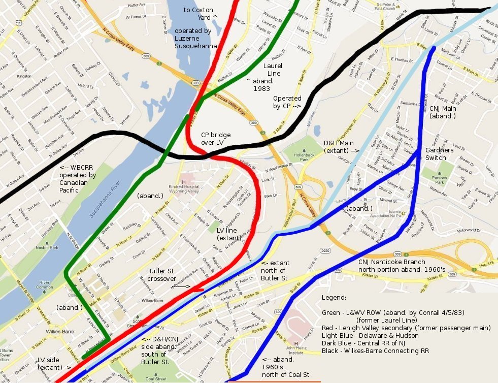
All the ex-CNJ and D&H trackage is now gone in the area of downtown Wilkes-Barre, but at Butler Street
there's a crossover from the LV track onto the former D&H ROW, and the D&H line continues from there north to Hudson.
At that (Hudson) junction, the line ends at a switch with the (now) Canadian Pacific line running north and southwest.
A big loss just north of downtown was all of the D&H facilities. Along the area just west of Wilkes-Barre Blvd,
the D&H had yard facilities just north of Market Street, and an engine terminal and roundhouse between there and Scott Street.
Here's an annotated aerial map of the area north of city center, centered on Scott Street.
This was cropped from a Penn Pilots photo dated June 23, 1959. Note that this was a good 20+ years before Wilkes-Barre Blvd
was built, and you will also notice that there was a vehicle overpass on Butler Street similar to the one on South Street today.

I began my tour of the area just north of Market Street. Here we are looking south, with Wilkes-Barre Blvd and the Stegmaier buildings
to the left. Straight ahead you can vaguely make out the cupola of the CNJ passenger station. The building at the right
is the Jewelcor Center. This area, along with the parking lot, was once the southern end of the D&H yard,
and the through tracks would have been a bit to the left, with the CNJ pair just east of the D&H ROW.

Looking to the southwest, we are looking across the ex-LV track (seen in the distance to the left of the trees),
and the Laurel Line terminal was once at the location of the Times-Leader building (bluish-white).

Looking north at the same location, what was once the D&H yard is now a grassy field.

Looking south, then north from just above Market Street is the ex-LV track. The small spire is a Citizens Bank branch.


Further north along the grassy area along Wilkes-Barre Blvd (but south of Scott Street), the LV track runs over a stone culvert.

Just north of Scott Street, looking south, the land is being re-graded again, and in the bushes nearby
was an old pile of railroad ties. This was all I found in the area, as far as D&H artifacts go.


Turning around here looking north just off Wilkes-Barre Blvd is the J&H Excavating Plant.

Back at Scott Street, the LV line passes over the street on a bridge, once carrying 3 tracks.

On the east side (just above the bridge), an old signal box remains, and on the other side, a cast-away rail section.


The front on this adjacent building is curved towards its north end, so it may have been railroad-related,
and where the back of the building abuts the bridge, we can see the ties used to buttress the ROW and provide a small gap.


Here are a few views from the underpass along Scott Street, the bridge is rusting away
and probably couldn't handle much more than the switcher-type engines the Luzerne Susquehanna uses over it.


Just south of Butler Street along the LV ROW we are looking south (first photo) and then north.
Here you can see the switch which curves off to the right. The LV line continues straight ahead,
while off to the right begins the former D&H line (heading north), which continues all the way to Hudson Junction.


Behind the truck terminal on the LV side, there's a siding with a few freight cars,
and adjacent to the front (east side) of the building, we see some layed-up Luzerne Susquehanna equipment.


Around the front of the building, the D&H ROW continues north towards Conyngham Street.

Here's a shot of where the LV track crosses Butler Street (looking west)...

... and where the D&H track crosses Conyngham Street, heading towards the expressway in the distance (looking north).

Further down Conyngham, past a car dealership, a few abandoned rails from an industrial spur remain.
There's actually a switch here, too, buried in the gravel.

Here we are looking south along the LV ROW a bit south of the corner of N Pennsylvania & E Chestnut Streets,
with an abandoned industrial siding to the left.

Turning around, we see a switch with a track branching off to the right (north).
This spur leads to the Lion Brewery Plant, successor to the Stegmaier name.


Stepping back a short distance from the Lion Brewery gate, there was once a connector here
going directly ahead to the D&H line, just as it approaches the expressway.


Here's where you arrive: Looking northeast where the D&H line crosses W-B Blvd heading towards Hudson.
You can see the underpass of the ROW under the North Cross Valley Expressway in the distance at the left of the photo.

Another view from the same spot looking south towards Conyngham Street.
The brick building straight ahead (painted with a McCarthy Tire ad) is the same one seen 10 photos above.

Back at Pennsylvania & Chestnut, we find an old storage box and bench along the tracks.

Going up Chestnut St to N Washington St, and making a right, the LV ROW runs down below the street in an underpass.


At North Main Street it crosses the street at grade.

Just to the north of here along North Main is also the WBCRR (CP) grade crossing,
but I'll cover that line on a separate page. Looking east from the medical offices
on the east side of River Road, we see the LV line approaching us.
The bridge you see is the WBCRR bridge crossing over the LV ROW.

River Road is a short distance behind us, and just recently, as of this writing,
a brand new highway overpass was installed over the tracks. From here, the line continues north,
paralleling the river and eventually arriving at the ex-LV Coxton Yard in Duryea.
Please see THIS page for photos from 2011 of the Luzerne Susquehanna
and Reading & Northern shop areas north of Pittston, along with a few glimpses of Coxton Yard.
I'll close this page with one last photo of the LV line where it passes under the Water St bridge in Pittston,
taken on December 27, 2010. Thanks for visiting !

Please close this window to return to the previous page, or HERE for the section index page...